Chiloquin’s nearby communities: Fort Klamath…. Crater Lake…. Rocky Point…. Sprague River….
Fort Klamath….
The Klamath name for the locality of Fort Klamath is Iukak, meaning “within” or “in the midst,” and refers to a location close to or between mountains. With the country embroiled in the Civil War in the east, the regular army had been called back, leaving the west exposed to uprisings and internal strife. The Oregon State legislature asked the US Congress for additional military posts, including one at the Klamath Lakes, to protect settlers and to quell any uprisings from the divided loyalties of the citizens. Not only were there conflicts between settlers and native peoples, but also there were Confederate sympathizers and those seeking to create a Pacific republic loyal to neither the Union nor the Confederacy.
Colonel C. S. Drew of the First Oregon Calvary was sent in 1862 to scout a location for an Army post. Drew surveyed the three recommended sites in the region and settled on one in the Wood River Valley north of Upper Klamath Lake, because the location had abundant water, ample pasture for horses and livestock, and extensive pine forests for fuel and building materials. The selected site was also situated where the Oregon Central Military Road met the trail between the Rogue River Valley and the settled regions in Eastern Oregon. Troop C, First Oregon Cavalry, led by Captain William Kelley, moved into the area in the fall of 1863 and began building the fort. The Modoc War of 1872-1873 was the most significant event of the fort’s 27-year history. A Congressional order closed the fort in 1889, and the last troops marched out of the post in June 1890.
Enough settlers had arrived in the Wood River Valley by 1888 for two adjoining landowners to donate two acres apiece for a school to be built one and a half miles northwest of Fort Klamath. Some 210 settlers were counted in the Wood River Valley in the Census of 1890. In 1894, the first store was built in the new town of Fort Klamath (although “store” quickly became shorthand for “saloon”). In 1896, a second store with a deed covenant prohibiting the sale of alcohol was opened. In 1902, the first plat survey for the new town was filed. By 1915, Fort Klamath was the third largest town in the county behind Klamath Falls and Merrill. As the trading center of the Wood River Valley during its early years, the town supported a cheese factory, a creamery, two garages, and a dozen or more mercantile establishments.
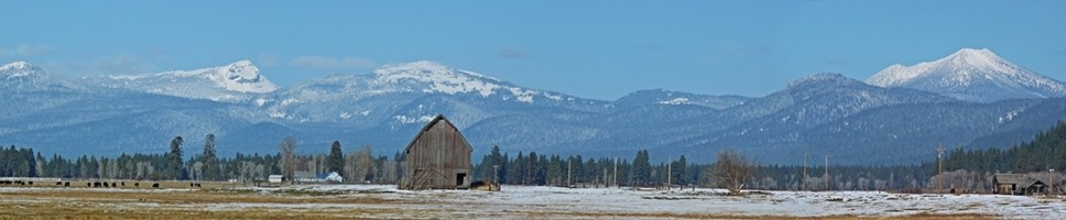
Now Fort Klamath is a quiet little town catering mostly to the ranchers of the rich grazing land surrounding the town, and tourists heading to Crater Lake.
Crater Lake….
To the Klamath tribes Crater Lake was Giiwas – a sacred place – and they did not mention its existence to early explorers and settlers. A group of miners from Jacksonville, Oregon, were the first white explorers to view the lake. The lake and the mountains around it were included in the Cascade Range Forest Reserve in 1893, and designated a national park by Theodore Roosevelt in 1902, in great part because of the efforts of William Gladstone Steel.
A native of Ohio, William Steel read of Crater Lake in a newspaper article. He first visited Crater Lake 1885, traveling by railroad and stagecoach to Fort Klamath, then walking the last 20 miles. He campaigned Congress for 17 years to designate Crater Lake as a national park.
Rocky Point….
Rocky Point Resort first appeared in southern Oregon history in the 1880s as Leavitt’s Point. It was a time when steamboats plied the waters of Upper Klamath Lake providing transportation to the growing population of settlers and logging companies clustered along the lake’s northern shore. In July 1910 the steamer Klamath began transporting passengers to Rocky Point from Klamath Falls to meet the Crater Lake Stage Line, which provided automobiles to complete the trip to Crater Lake. This new, improved service allowed travelers to journey from Klamath Falls to Crater Lake in the record time of 12 hours!
Along with tourism, logging was once an important part of the area’s economy, starting in the early 1900s. There was a sawmill in nearby Odessa that operated for several years. Located within the Winema National Forest there are no longer any large-scale lumber operations, however since late 19th century Rocky Point has been the site of a lakeside fishing resort of summer-only residents, and now hosts permanent residents as well as many miles of canoe trails.
Sprague River….
Sprague River was named for Captain F.B. Sprague, who was a participant in various phases of the Snake and Paiute Indian wars, and commanded at Fort Klamath in 1866. The Klamath Indian name for Sprague River is Plai, or Plaikni Koke. Koke is the general word for river, and plai indicated that the stream came from the upper or higher country. The town of Sprague River was laid out on the bank of its namesake, four miles southeast of the Yainax Sub Agency of the Klamath Indian Reservation. The town was established by Frank Mutto, subagency superintendent, and Benjamin E. Wolford, a Yainax storekeeper, during May 1923 – the same year that the OC&E Railway arrived at that location.
The first structure was Wolford’s combination store and post office building, which was moved from Yainax. The first mill, located about a half-mile from town near the new OC&E Railroad terminus, was incorporated under the name of the Sprague River-White Pine Lumber Company and began operations in 1925.
These days there is no mill, and Sprague River has followed the path of most of the towns in the area, becoming smaller with the passing years.